TORNADO SURVEY UPDATE: National Weather Service confirms 10 more tornadoes during April 26 storm
Nearly a week after storms hit, NWS confirms at least 19 tornadoes, 5 significant EF-3 tornado paths
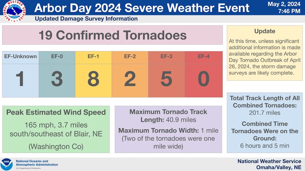
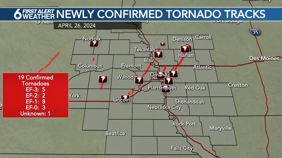
OMAHA, Neb. (WOWT) - The National Weather Service has now confirmed 19 tornadoes from the outbreak that struck eastern Nebraska and western Iowa on Friday, April 26.
The latest report, issued Thursday night, adds 10 to the 9 initial tornadoes confirmed earlier this week.
The Omaha NWS reports that right now, unless significant information is made available, the storm damage surveys are likely complete.
DETAILS ON NEW TORNADOES
The newly issued tornadoes include:
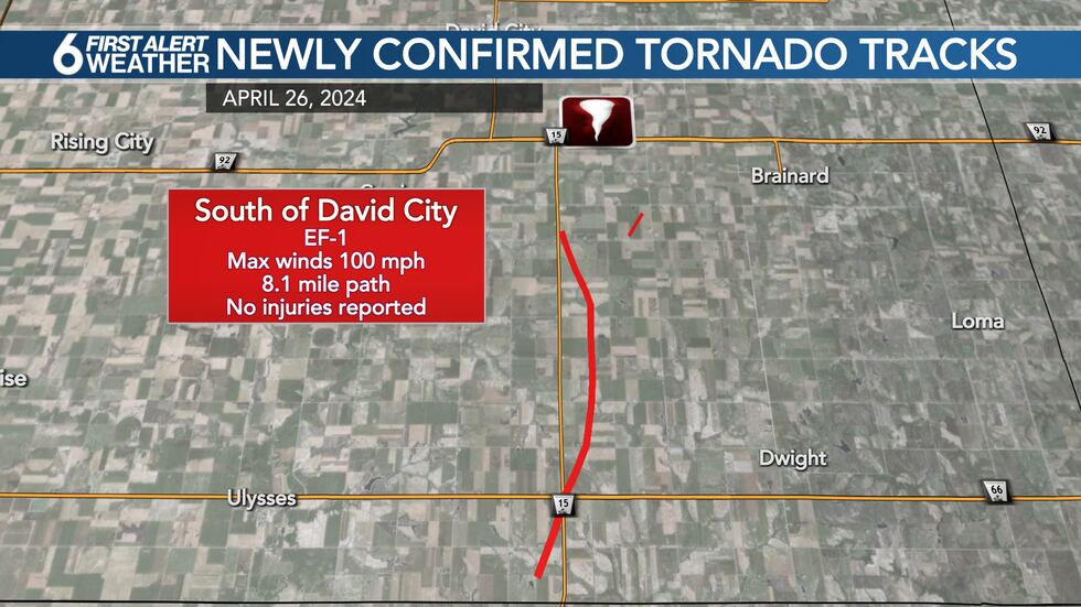
South of David City EF-1: This tornado developed around 2:51 p.m. in Butler county and tracked North along Highway 15. It ended around 3:07 p.m. Peak winds came in at 100 mph with a path length of 8.1 miles and a max width of 200 yards. No injuries or deaths were reported.
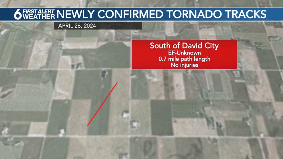
South of David City EF-Unknown: Another tornado developed briefly immediately east of the first tornado. It started around 3:06 p.m. and ended around 3:07 p.m. The path length was 0.7 miles with a max width of 30 yards.
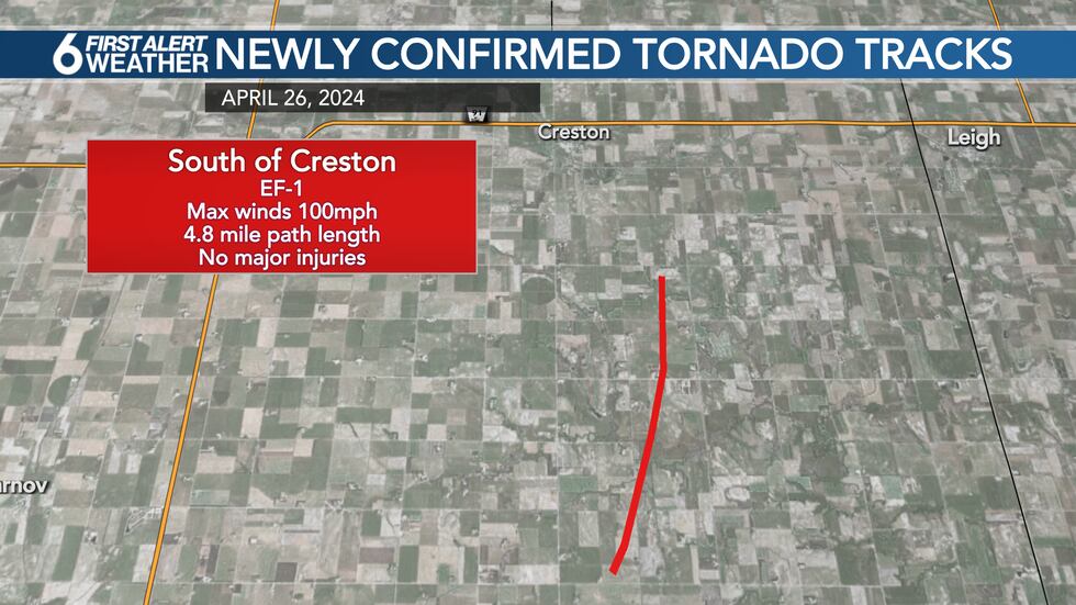
South of Creston EF-1: This tornado developed around 4:07 p.m. in Platte county south of Creston and tracked NNE. It ended around 4:20 p.m. three miles SSE of Creston. Peak winds came in at 100 mph with a path length of 4.8 miles and a max width of 100 yards. No injuries or deaths were reported.
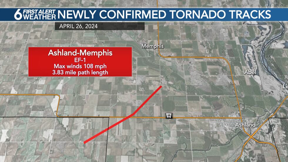
Ashland - Memphis EF-1: This tornado developed around 3:12 p.m. in NE Lancaster county and tracked NE. It ended around 3:18 p.m. to the northwest of Ashland and south of Memphis. Peak winds came in at 108 mph with a path length of 3.83 miles and a max width of 50 yards. No injuries or deaths were reported.
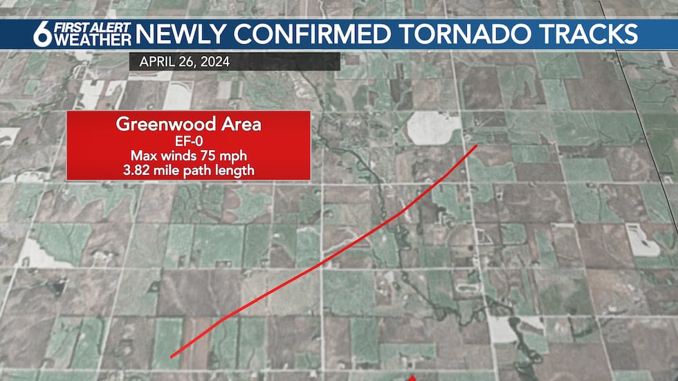
Greenwood EF-0: This tornado developed around 3:03 p.m. in Lancaster County, north of Waverly and NW of Greenwood and tracked NE. It ended around 3:07 p.m. Peak winds came in at 75 mph with a path length of 3.82 miles and a max width of 30 yards. No injuries or deaths were reported.
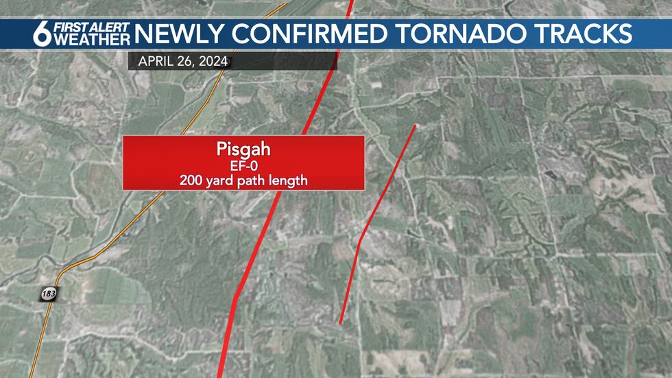
Pisgah EF-1: This tornado developed around 4:52 p.m. in NW Harrison County and tracked north with its path just to the east of Pisgah, IA. It ended around 5:09 p.m. in southern Monona County. Peak winds came in at 110 mph with a path length of 9.32 miles and a max width of 766 yards. No injuries or deaths were reported.
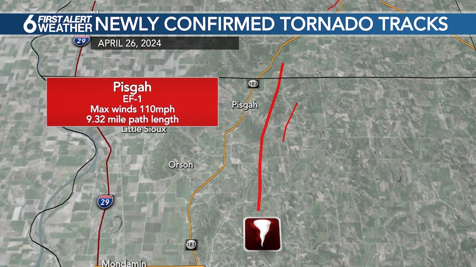
Pisgah EF-0: A second tornado developed in the same area around the same time at 4:59 p.m., lasting until about 5:04 p.m. with a path length of 2.64 miles and a max width of 200 yards. No injuries or deaths were reported.
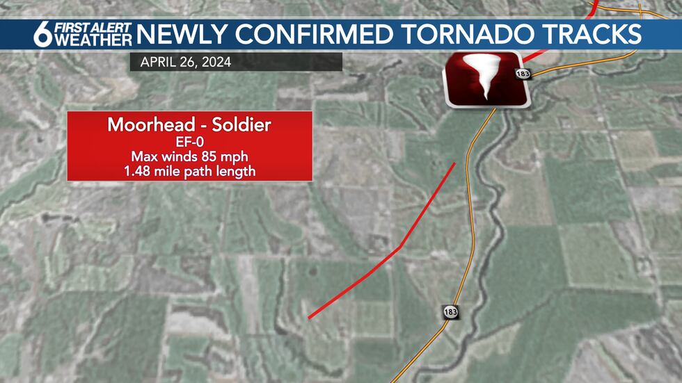
Moorhead-Soldier EF-0: This tornado developed around 5:17 p.m. in Monona County and tracked NE just west of Soldier River, between Moorhead and Soldier, IA. It ended around 5:19 p.m. Peak winds came in at 85 mph with a path length of 1.48 miles and a max width of 100 yards. No injuries or deaths were reported.
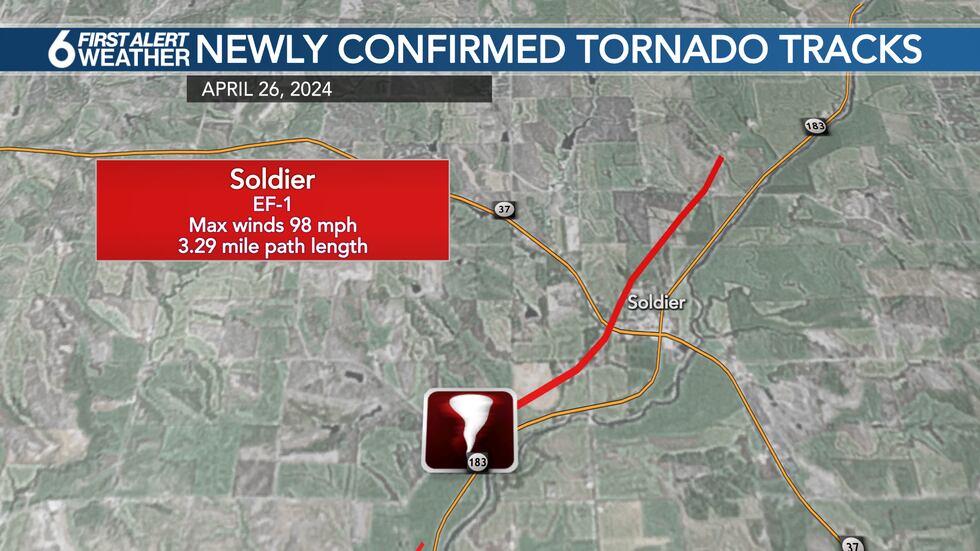
Soldier EF-1: This tornado developed around 5:23 p.m. in Monona County and tracked NE along the western edge of Soldier, IA. It ended around 5:30 p.m. Peak winds came in at 98 mph with a path length of 3.29 miles. No injuries or deaths were reported.
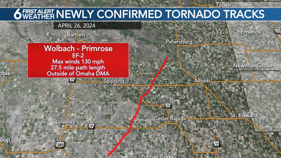
Wolbach - Primrose Areas EF-2: This area is not part of the 6 News coverage area, but is included in the Omaha NWS area. This tornado developed in Greenley County around 2:04 p.m. and tracked NNE to the west of Primrose and ended around 3:10 p.m. in Boone County, SW of Petersburg. Peak winds came in at 130 mph with a path length of 27.5 miles and a max width of 500 yards. No injuries or deaths were reported.
—
Keep up with the latest severe weather in your area. Download the 6 First Alert Weather app.
Copyright 2024 WOWT. All rights reserved.


